Visit Sydney Australia


Lost Sydney: Waterways
One of the major influencing factors in Gov. Phillip's choice of Sydney Cove above other bays in Port Jackson for the site of the settlement was a ferny creek. It flowed north from swampy high ground located within the area bounded by Market, Park, Elizabeth and Pitt Streets through a small, closed valley and into the cove through a tidal estuary. It was fed and filtered from the see pages of mosses and undergrowth that provided the spongy cover of its porous sandstone base.Sydney Red Gums (Myrtles), Banksias, Acacias (Wattles), Cabbage Tree Palms and Tree Ferns shaded an undergrowth of orchids, ferns, plants and flowering shrubs which thrived in the shaded environment of rotting leaves, bark and boughs of fallen trees. The nature reserve of Parsley Bay at Vaucluse, some 6 kilometres west of Sydney Cove, with its rivulet, small closed valley and rainforest vegetation, gives an inkling as to what Sydney Cove of 1788 must have been like, being today much as it was when Captain Philip first found it. A wander through this reserve is like a walk back in time.
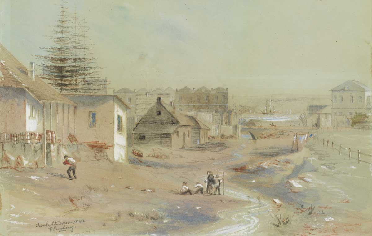
The creek which flowed into Sydney Cove became known as The Tank Stream, and it was the colony's first water supply. A defined channel through which the water could flow was formed by the colonists from King Street. A small weir was built to catch the water and to stop rising tides from making the water salty where Pitt and Crane Streets intersect today. Within a short while other similar 'tanks' were carved out of the sandstone to catch the water, which is why the creek became known as The Tank Stream.
A simple log bridge was built across Tank Stream near the the military barracks, giving rise to the walkway which later was to cross the stream at this point being named Bridge Street. In 1804, Gov. King had the log bridge replaced by a more sturdy stone bridge. It was remodelled in 1810 by John O'Hearne whose labour was paid for with 675 gallons of rum.
So where is the little rivulet that once flowed into Sydney Cove? The first settlers did not realise that clearing the trees and underbush loosened the topsoil which kept the mosses, ferns and undergrowth in its moist state. Within two years, the creek had become polluted. Construction of new dwellings in the 64 ha catchment area was belatedly banned and tanks were built near Bridge Street to retain what little water still flowed, hence its name Tank Stream. In 1804, a last ditch effort was made to protect the stream. The Governor declared a 15-metre wide green belt on either side of the stream where cutting timber and grazing stock was forbidden, but the damage already done was irreparable. By 1826, Tank Stream had ceased to be used as a water supply, being replaced by an underground channel known as Busby's Bore which brought water from Lachlan Swamps in Centennial Park to a reservoir in Hyde Park.
As there was no need to retain what was left of the stream, the land around it was sold off and developed and what was once the lifeline of the town became an underground drain. Sections of the system of tunnels built to drain the Tank Stream into Sydney Cove still exist today, taking away the excess rainwater from Sydney's streets. A brick section of the tunnel (below) between Angel Street and Australia Square is over 140 years old.
In 1860, The Tank Stream was covered from Hunter Street to Bridge Street. At Bridge Street it was connected on to an open stone drain which ran along the original course of the Tank Stream through private property to connect up near the present site of Crane Place with an elliptical stone sewer. In 1866 a sewer was constructed along the route of the Tank Stream between Hunter and King streets, part of which remained, for a time, uncovered. The erection of the General Post Office, the formation of Martin Place during the 1870's and the later widening of that thoroughfare necessitated the covering of the central portion. In the same year, a diversion to the route of the Tank Stream was made between Bridge Street and Crane Place.
Additions to the GPO in 1940 necessitated the reconstruction of part of the Upper Tank Stream between Martin Place and King Street. When Australia Square was built, the Tank Stream was diverted around its foundations via a new concrete tunnel. Today its memory is recorded in the names Tank Stream Way, Tank Stream Arcade and Bridge Street. The latter was thus named because it once crossed over the Tank Stream where Tank Stream Way and Bridge Street now meet.
After The Tank Stream, the creek which flowed into Farm Cove (Wuganmagulya) was the most important waterway to the early colonists of Sydney as it provided the water for the colony's farm located within the grounds of what is today the Royal Botanical Gardens. The root vegetables grown there thrived, but such was not the case with cereal crops about which Gov. Phillip, in his report of 28th September, 1788, said, "very little of the English wheat had vegetated and a very considerable quantity of the barley and many seeds had rotten in the ground ... all the barley and wheat likewise destroyed by the weevil."
The first fleeters weren't the first humans to utilise the land surrounding the small creek, however. The Aborigines appear to have used it as a meeting place for the various groups up and down Port Jackson long before the arrival of the white man, as they held a corroborree there during the first years of the colony. Corroborees were only held at set meeting places.
Farm Cove Creek is today the only watercourse in the inner city area which not only still flows but follows its original course as it wends its way through the Botanical Gardens.

Site of the bridge over the Brickfields Creek which led to the farm of Surgeon John Harris
Early colonial records indicate that a simple log bridge carried the road to Parramatta across the main creek near the Brickfields settlement's brick kilns. First marked on a map dated 1891, this bridge was located somewhere near the intersection of Hay and Pitt Streets. The section of Pitt Street between Hay Street and Railway Square was originally the beginning of Parramatta Road which began at the bridge.
According to a map dated 1802 drawn by French explorer Francois Peron, a bridge also existed over a small creek which flowed into Darling Harbour on its western side. That bridge was located where the flyover takes the Western Distributor over Pyrmont Street. The path which crossed the creek at the bridge provided access to the farm of Surgeon John Harris and followed the line of Harris Street. The creek is believed to have had its source within the site of the Sydney Institute of Technology, Ultimo. It is now an underground drain.
UBD Map 3 Ref B 14

Sophia Street
A water course which passed through a tiny settlement of brickmakers late in 1788 began in the vicinity of the intersection of Riley and Foveaux Streets and flowed along the line of Sophia Street, then north in front of the Albion Brewery (Centennial Plaza is built on the brewery site) and through what today is Belmore Park. The section of Hay Street to the east of George Street, which was added after the creek was turned into an underground drain, follows the path taken by the creek to the marshes which encircled the head of the Cockle Bay (Darling Harbour) where the Entertainment Centre is today.
In the 1880s, Quay Street extended north as Lackey Street to the Darling Harbour railway goods yard built around a semicircular wharf at the head of Cockle Bay. A tributary of the main creek began as a spring near present day Hills Reserve in Surry Hills. Little Albion Street follows the path of the creek which cascaded down the hillside on the western side of Crown Street in what became known as Frog Hollow. This small valley was a notorious hideout for criminals in Victorian Sydney.
UBD Map 3 Ref K 15

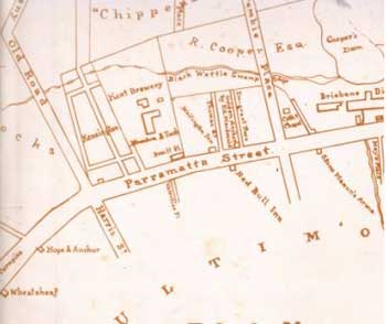
Coopers Distillery on Black Wattle Swamp Creek, 1868
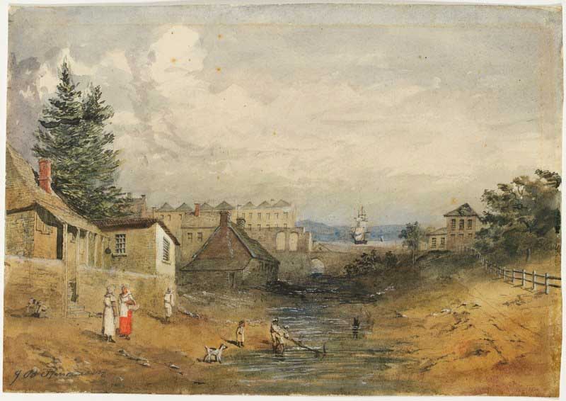
A bridge took Parramatta Street (now Broadway) over Black Wattle Swamp Creek (later called Blackwattle Creek), an important watercourse in Sydney's colonial days. Black Wattle Swamp Creek rose in a swamp where Prince Alfred Park is today and passed the old brewery on Broadway - it was the brewery's water supply and the reason for the plant being located there. The creek then followed the line of Blackfriars Street, entering Blackwattle Bay in a large swamp where the Sydney City Council Depot in William Henry Street now stands.
A tributary of Black Wattle Swamp Creek had its source beyond Erskineville Railway Station near the corner of Ashmore Street and Binning Lane. The railway corridor south was in fact built alongside the creek. The northern boundary of the Eveleigh Railway Workshops followed the creek. Boundary Lane, Boundary Street and Smithers Street follow the line of the creek.
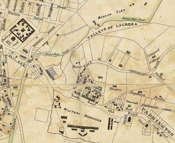
Map dated 1842, showing Black Wattle Swamp Creek
Another branch began in the swamps at Grose Farm (now Lake Northam in Victoria Park, Darlington). It entered the main creek near the corner of Blackwattle Lane and Kelly Street. The path of another branch can be traced on modern maps. Vine and Hudson Streets, as well as Stirling and Short Streets, Redfern, were built on opposite banks of the creek that began as a spring in the vicinity of Pitt Street, Redfern. Today the creek and its branches flow into Blackwattle Bay via a complex system of underground drains.
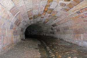
Comprising of 1,700m of covered canal, an 900m long old Council sewer, 700m of box culvert, 1,200m of concrete pipe and 100m of brick, parts of the Blackwattle Bay drain system are the oldest drains in Sydney. Built in the 1850s as an open canal running through the centre of Wentworth Park then on between buildings up to Broadway, the canal was capped in 1879 as reclamation of Blackwattle Swamp neared completion. In the process Blackwattle Lane was created, which is basically the rooftop of the tunnel. Twin box culverts head diagonally east away from the covered canal, eventually meeting up with and running parallel to an old convict built 1850's brick oviform tunnel (balloon, or upside down raindrop shaped tunnels) that was built as a harbour bound sewer.
The convict tunnel is the second oldest tunnel in Australia (after Busbys Bore), being older than the Tank Stream tunnel which was built in 1858. Only 250 metres of the sandstone slab arch tunnel survives. It features bricked up side pipes and numbers carved into each block, a tally to ensure the convicts kept their quotas up.
UBD Map 12 Ref Q 15

This creek which still enters Rushcutters Bay but via a concrete drainage channel today once flowed through what was known by the exotic name of the Valley of La Croza. Located within the 40-acre (16.2 hectare) grant of William Thomas, the steep, picturesque valley has also been known as West's Bush and Barnum Glen. West's Creek, which has also appeared on maps over the years as La Croza Creek and Rushcutters Creek, rose near present day Chisholm and Sims Streets, Darlinghurst and flowed through a series of races, pools and falls. The lower section, which flowed through the 70-acre grant of Thomas West which was located south east of Bayswater Road, joined another creek which today flows through Trumper Park and enters Rushcutters Bay via a concrete channel.
The Valley of La Croza attracted weekend picnickers from all parts of Sydney in the early years of the 19th century. Though the upper section of the creek has long since dried up, its path is still recalled in the top end of Barcom Road, Paddington, the whole of Boundary Street and the eastern section of McLachlan Avenue which follow what became its dried up bed in the 1860s. The valley and a number of Chinese market gardens below the creek on the flats were subdivided and sold under the name of Barcom Glen, a corruption of the latter name Barnum Glen, in the 1880s.
UBD Map 4 Ref L 14
Stream Street follows the course of Palmer's Creek
Though there are no records to indicate the existence of a creek by that name, it is not only likely but almost certain that the creek which once existed to the east of what is now The Domain on the western extremity of the city of Sydney was called Palmers Creek. The reason for this presumption is that it flowed into Palmers Cove, now Woolloomooloo Bay.
It was common practice among early colonial governors to give a creek the same name as the bay it flowed into. The name honours John Palmer, purser of HMS Sirius, one of a number of first fleeters who were buried in and have a marked grave in St. Johns Cemetery, Parramatta. Palmer, the colony's first Commissary, was granted the land through which the creek flowed. It has also been called Yurong Creek, perhaps its Aboriginal name and the reason why the street which followed its the western bank was called Yurong Street.
The creek rose in the vicinity of the intersection of present day Forbes and Bourke Streets. From this point it flowed north westerly down the hillside crossing Crown Street near Liverpool Lane. It then continued north towards the corner of Boomerang Place and William Street where it then followed the line of present day Sir John Young Crescent to enter Palmers Cove at its head.
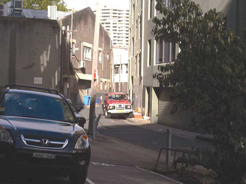
In addition to the un-named squiggly line on contemporary maps, the existence of the creek is recalled in Stream Street (above), a curved laneway in East Sydney between Yurong and Stanley Lanes. Its shape and name are evidence that it follows the course of a small section of the creek as it passed through the area. The western section of Busby Lane also follows the line of the creek. A short tributary of the creek which rose in the vicinity of the site of Sydney Grammar School in College Street flowed along what now is the eastern edge of the fragrance garden of Phillip Park, entering the main creek at the northern corner of Busby Lane.
UBD Map 3 Ref K 15