


Frenchs Creek lower falls
Frenchs Creek Track
Location: BelroseFrenchs Creek to The Cascades is a 4.5 km out and back trail, rated as moderate and primarily used for hiking, walking, and trail running. The trail utilises the badly eroded Frenchs Creek Track and gives access to the middle eastern section of Garigal National Park in Sydney's north, following Frenchs Creek. Vegetation is light scrub on the hillsides with some larger trees in the valley. A major feature on this walk are two waterfalls on the upper reaches of the creek. The track begins at the end of Wannita Road, Belrose.
This is a very popular area for hiking, running, and walking, so you'll likely encounter other people while exploring. The trail is open year-round and is beautiful to visit anytime. You'll need to leave pups at home — dogs aren't allowed on this trail. This walk follows the creek and passes several beautiful waterfalls on its way to the suburb of Davidson. It is an enjoyable budh walk listening to the sounds of birds, bees and running water.
Frenchs Creek Upper Falls
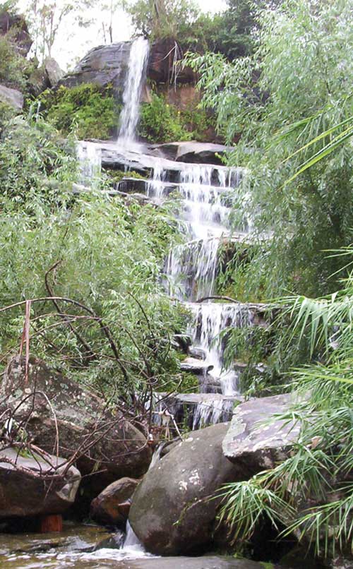
After Oxford Falls, Frenchs Creek Falls in Belrose would have to be the most visually stunning of all waterfalls of the inner Sydney metropolitan area. They consist of a pair of giant steps a hundred or so metres apart over which the creek flows on its way from the top of the escarpment into the valley below. Access to the top of each falls is good, however for the best view (from the rock pools at their base) one has to struggle down a steep, rugged hillside while pushing through dense undergrowth. This can be quite dangerous, especially after rain when the foliage overhead and ground underfoot is damp, slippery and unstable. Unfortunately, this is when the falls are at their most spectacular.
Frenchs Creek is a tributary of Middle Harbour Creek. The names of the track, the creek and waterfalls recalls James French, a special constable and crown land ranger, who came to the area in 1846 after acquiring 46 acres there, it being named Frenchs Forest after him.

The Cascades
The trail leads to a series of beautiful little waterfalls, rock platforms and rockpools at the junction of Middle Harbour creek called The Cascades, a lovely spot to pause and enjoy a picnic. By taking the Cascades trail, you’ll leave the valley travelling up the sometimes steep trail to an exit onto Stone Parade, Davidson.
