


Waterfalls and Cascades: North
As might be expected, all waterfalls in the Sydney region are at their best after heavy rain, in fact some don't even flow at other times due to the alteration of drainage patterns through urbanisation. If visiting the more remote waterfalls after rain, be prepared for the soil underfoot to be muddy and slippery, especially if you have to leave a well worn track. Even if you stay on a path, be prepared for sections to have been washed away after a heavy downpour. Everything - the soil, the undergrowth, the trees above - will be wet and slippery.

Beyond the beach at the head of Shell Cove, Neutral Bay, on Sydney's lower north shore is a waterfall that has somehow managed to survive the encroachment of suburbia. The creek which feeds it is now a stormwater drain that flows under the house at 6 Bogota Avenue, Neutral Bay, before dropping its water over the falls. Being fed only by run-off, the waterfall only functions after rain. Shell Cove is just 5 km from the city centre. The falls are near the beginning of a popular foreshore walk around Cremorne Point.
- Get Directions
- Get Directions
- Get Directions
- Get Directions
- Get Directions
- Get Directions
- Get Directions
- Get Directions
- Get Directions
- Get Directions
- Get Directions
- Get Directions
- Get Directions
- Get Directions
- Get Directions
- Get Directions
- Get Directions
- Get Directions
- Get Directions
- Get Directions

These 5-metre falls on McCarrs Creek are located on one of the most picturesque drives in the Sydney metro area. McCarrs Creek Road commences in Terrey Hills. The falls are near the National Park's south-eastern entrance off McCarrs Creek Road below the first bridge across the creek when approached from Terrey Hills. The valley of the gorge offers the best view of the falls and the pool, but there is no path, so care must be taken if attempting a descent into the gorge.
The valley of Gore Creek on Sydney's lower north shore is a beautiful, tranquil strip of bushland that has managed to survive the urbanisation of the surrounding area. The walking track alongside Gore Creek gives access to the Lane Cove Bushland Reserve which is dissected by River Road at Northwood. The section below River Road contains the picturesque Lilly Pilly Falls which can be viewed at close range via stone steps.
The falls and water pool below it were once a popular picnic and bathing spot. Urban development upstream has severely affected the amount of water coming over the falls and he pool is heavily silted, but they are still quite impressive after heavy rain. Gore Creek enters Lane Cove River through Gore Creek Reserve where barges were loaded with timber cut from the surrounding area.
Vegetation north of River Road is a mix of open forest and rainforest, the latter being predominant in the steep-sided gullies of the upper section where the creek flows through a series of pools and races. A century ago, Paddy's Flats, located above a series of rapids, was once lush, shaded pasture where cattle grazed. Access to the reserve is from St. Vincents Road, Greenwich; Ronald Avenue, Gore Hill; River Road, Northwood; Cogan Place, Osborne Park .
The walking path to Sangrado Pool on Powder Hulk Bay, Middle Harbour, holds a special surprise - a picturesque waterfall in a pocket of rainforest. Located beyond the end of Sangrado Street, the falls are located in Sangrado Park, a nature reserve behind a small beach on Powder Hulk Bay. About 50 steps take the walking track down to water level, after which it passes through the valley via a walking track past the waterfall.
Yarralumla Wildlife Sanctuary in North Rocks follows the bushland valleys of Hunts and Pages Creeks, tributaries of Darling Mills Creek which flow into Lake Parramatta. A haven for local native flora and fauna, the 2.3 km long reserve has a walking trail beside the creeks which can be accessed from Statham Avenue and Northam Drive, North Rocks and Lindisfarne Crescent, Carlingford. Upstream from the confluence of the two creeks, Pages Creek passes over a particularly beautiful waterfall. It can be accessed with ease from Panaview Crescent, North Rocks or Ferndale Avenue and Edinburgh Avenue, Carlingford.

In the days before Sydney's lower north shore had become part of suburbia, the runoff from the hillsides of Willoughby, Northbridge, Narremburn and Crows Nest drained into Flat Rock Creek. The creek flowed over the cascades and down through the steep valley now occupied by Munro Park and Tunks Park before emptying into Long Bay and Middle Harbour. The parks, which were created by the filling in of the middle section of the valley in the 1920s, contain a number of playing fields. A walk up the valley to the falls is a rewarding experience.
The view upwards as you pass under the Northbridge Suspension Bridge is not something one sees every day. Beyond the bridge is the rock quarry from which stone for the bridge piers was hewn and brought to the construction site by barge. The path then wanders through the serene natural bushland of the upper valley. After the path crosses the creek via stepping stones, the valley narrows and becomes a gorge. Here the creek passes over a series of picturesque cascades. Two steep paths lead from the cascades to Flat Rock Gully Reserve and Bicentennial Reserve on Small Street, Willoughby. Dawson's Track passes the ruins of the stone house of a hermit Fatty Dawson.
A 16 metre high waterfall that flows deep in the relatively untouched bushland of Garigal National Park at the northern end of Bantry Bay. Featuring evidence of Aboriginal occupation in the overhangs nearby, the falls are hard to reach these days as a track to the base of them was swallowed up by regenerating bush after a fire swept through the valley in the 1980s. Access, such as it is, is via the Cook Street Track which has entry points in Cook Street and Currie Road, Forestville. The Bay and Magazine Tracks take bushwalkers past three smaller races and falls on the Main Creek.
The Bay Track can be accessed from the eastern shore of Bantry Bay or from the end of Grattan Crescent. When walking the Bay Track you will come across the Natural Bridge Track. The natural rock bridge to which it leads is nestled deep in the valley and takes the track over Main Creek. The track continues up the steep hill to the Bluff Lookout which offers panoramic views south across Bantry Bay.
One of Sydney's prettiest and least visited beaches, Collins Flat Beach is at the head of Spring Cove near Manly. The beach's name honours Capt. David Collins, Judge Advocate with the First Fleet who was present when Gov. Arthur Phillip was speard here by an aborigine on 7th September 1790. Gov. Phillip went here by boat to meet with an Aboriginal named Bennelong.
As Phillip stepped forward to greet him, one of a group of natives with Bennelong, believing him to be in danger, intercepted the Governor and threw a spear which pierced Phillip's shoulder. Lt. Henry Waterhouse, Midshipman of HMS Sirius, broke off the spear as the Governor bled profusely. He was taken back to Sydney where he was operated on and the barb was removed. He returned to duty 10 days later.
As well as having historic connections, the beach features a small waterfall at its head. It is fed by a creek that drains most of the runoff from the high ground of North Head into Spring Cove. Best viewed after rain, as it reduces to a trickle at other times. Access to the beach is by boat or on foot only from Collins Beach Road.

If you traveverse the Spit to Manly Walkway, be sure to stop of at Castle Rock Beach in Balgowlah, midway along the walk. This isolated beach is a delightful place few people know about where the water from a creek tumbles down the hillside, over a rocky ledge and onto the beach before running into the Harbour. Access from the end of Ogilvy Road, Balgowlah.
Deep in the heart of Ku-Ring-Gai Chase National Park on Cowan Creek is Refuge Bay. Across the head of the bay are cliffs over which flows a creek, tumbling into a pool on the beach before entering Cowan Creek. This secluded little corner of Paradise is a popular place for launches to anchor and for their occupants to take a cold water shower under the waterfall. Access is by boat only.
When travelling on the Spit to Manly Walking Path, the first bay reached after leaving The Spit is Fisher Bay. Two small creeks flow into the bay after rain, the most visible one is a small stream of water which cascades down the cliff face alongside the walking path before flowing across the sandy beach into the bay. Due to the level of urban development in the surrounding area, the falls no longer flow all year round. The photographs shown were taken on a day following a day of heavy rain.

Carlyle Falls, Moores Creek
Take a pleasant walk through the bush starting at the corner of Merlin Street and Roseville Avenue, Roseville along the Little Diggers Track. This well maintained track follows Moores Creek through a fern gully. Along the way you pass numerous caves where evidence of Aboriginal habitation has been found, passing Casuarina woods, Llewellin Falls, Carlyle Falls, Little Falls, Babbage Falls and Goblers Glen.
Little Falls
Continue on via the Two Creeks Track to Middle Harbour, or a shorter walk, enter or exit the track via an accessway at the back of the children's playground on Carlyle Road. The falls beyond the bridge across Moores Creek near Carlyle Road is unusual in that the water does not flow over the rocky ledge of the falls but through it, the falls themselves being inside a rock ledge.
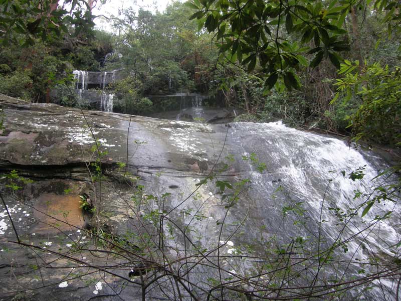
Manly Dam Reserve on Sydney's northern beaches is an important area of urban bushland which has for years has been a place to relax and unwind for local residents. The Manly Creek (formerly Curl Curl Creek) Circuit Track is an easy 8 km pathway through the bush which loops Manly Reservoir. On the way are numerous scenic vistas, Aboriginal rock carving sites and two waterfalls over which Manly Creek falls on its way from the Allambie Heights plateau to Manly Dam.
Willoughby Falls is the only one of a number of big waterfalls on the middle and lower sections of Middle Harbour to have survived the encroachment of urban development. Before the arrival of white man, the area at the base of the falls that is today known as Primrose Park was a feasting site for the local Aboriginal peoples. The earth and area surrounding the tip of Folly Point is full of the remnants of shells and bones.
After colonisation, the location was a popular picnic spot to which north and south shore residents alike would walk to the waterfall's base via a bush track from a jetty on Willoughby Bay. Alternatively, they would approach the top via a bush track to Folly Point which became Cammeray Road. The construction of a sewerage works and septic tanks, the remains of which can be seen today in Primrose Park, stemmed the stream of visitors to the falls, though this trend was reversed when the works were closed and the area opened up for use by sporting groups.
The retention of the open space of Cammeray Golf Course above the falls has preserved enough of the catchment to keep the stream flowing all year round. Underwater channelling from the golf course to the head of the falls, along with the preservation of a small pocket of bush around the cascade has ensured the location has retained as much of its charm as is possible in a built up area. Unfortunately the track to the base of the falls from Primrose Park has not been maintained so access from the park, whilst possible, is a bit of a scamble.

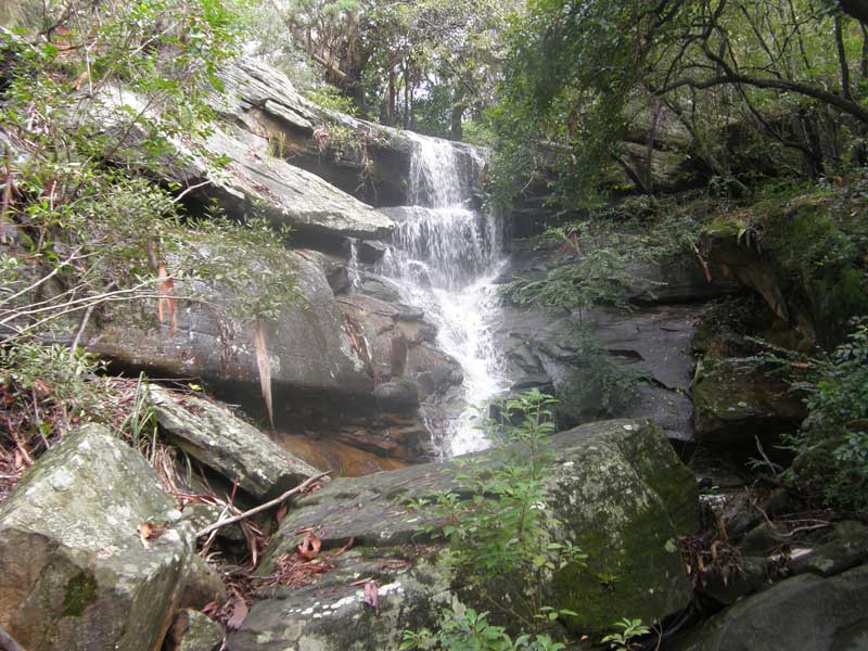
There are many small waterfalls and rapids on the creeks of Sydney's upper north shore and this is one of the more well known and accessible of them. Located in St. Johns Bush, it is a short, easy walk from the lower end of St Johns Ave. beyond the Gordon Golf Course. A bridge crosses the creek above the falls though the view of the falls there says is partly obscured by bush. A walking path leads to the falls, which has two drops of approx. 3 metres each. The walking path joins with the Blackbutt Track, a fire trail which leads to Blackbutt Reserve through which flows Blackbutt Creek.
The valley of Brickmakers Creek, which flows into the Lane Cove River at Boronia Park in Gladesville, was for centuries a campsite for the local Aborigine. Evidence of their camps abounds in the midden deposits and rock art throughout the park. The main attraction for the natives was the creek which provided a year round supply of fresh water. In what is now Boronia Park, the creek tumbled into a small valley over what was named Tipperary Falls to the white settlers.
The now silted rock pool which once existed at the base of the falls was used extensively by the Aborigines not just as a watering place but to sharpen their stone tools. In early colonial days, the location became a popular picnic spot and swimming hole and remained that way well into the 20th century when urban development in the creek's catchment area caused its strong flow to be reduced considerably.
The waterfall flows best after rain and this is the best time to visit. While there, take a walk to the river foreshore where there is a smoke-blackened cave and midden, both evidences of its use as an Aboriginal campsite. A surveyor has marked the letters "BM 1831" into the rock near the falls.
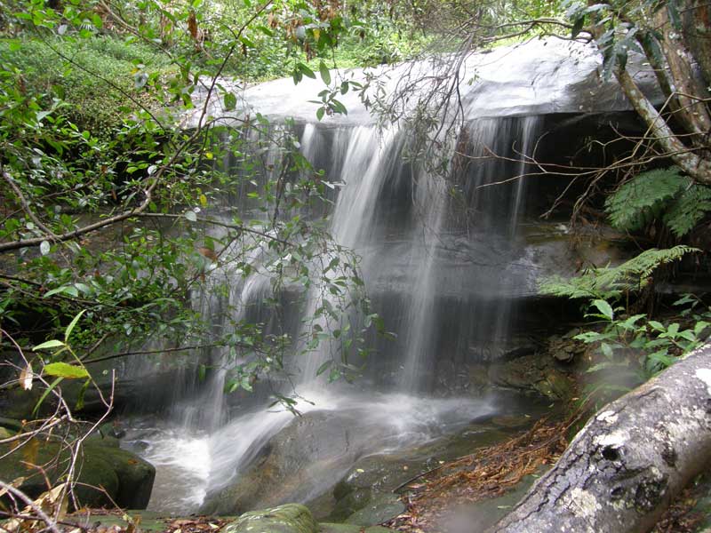
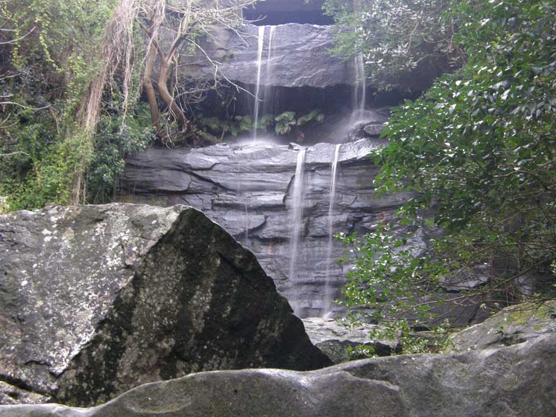
After Oxford Falls, a pair of waterfalls on the upper reaches of Frenchs Creek at Belrose would have to be the most visually stunning of all waterfalls of the inner Sydney metropolitan area after rain. Located off the badly eroded Frenchs Creek Walking Track in Garigal National Park, they consist of a pair of giant steps a hundred or so metres apart over which the creek flows on its way from the top of the escarpment into the valley below.

Upper Frenchs Creek Falls
Access to the top of each falls is good, however for the best view (from the rock pools at their base) one has to struggle down a steep, rugged hillside while pushing through dense undergrowth. This is quite dangerous, especially after rain when the foliage overhead and ground underfoot is damp, slippery and unstable. Unfortunately, this is when the falls are at their most spectacular. Access is via the walking track at the end of Wannita Road, Belrose.
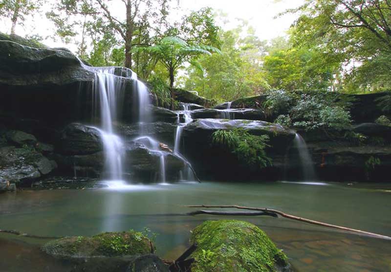
Mullet Creek passes over a series of three falls and cascades on its way to Narrabeen Lakes in Sydney's northern beaches. The most easily accessed is the lower falls which is a short level walk from the corner of Irrawong Road and Epworth Place, Warriewood. A very picturesque rock overhang provides shelter for picnickers and a pool which for years was a popular swimming hole.
Middle Creek (not to be confused with Middle Harbour Creek) makes two drops into the valley of picturesque Oxford Falls Recreation Reserve where Oxford Falls Road fords the creek at Oxford Falls. Though the falls are the highest in the Sydney metropolitan region, there is no viewing platform, and the only way to see them is from the head of the falls lookin g over the top or from the valley below which is dense bushland.
At the southern tip of Killarney Heights is a beautiful, secluded bay with a small beach. Behind the beach the waters of Flat Rock Creek tumble down the escarpment in a number of spectacular falls and races before entering the bay at the head of the beach. The beach and the falls behind it can be accessed via the Flat Rock Walking Track from Killarney Point, from a track at the end of Killarney Drive and from the Magazine Track which passes behind the historic Bantry Bay explosives compound. Access to the falls at various stages of its descent into the harbour is available off the Killarney Drive track but should not be attempted unless you are a confident bushwalker.
Butt Park, named after Francis Walter Butt, a Willoughby resident and Alderman 1937-41, is located on Eastern Valley Way. It is through this small reserve that Sugarloaf Creek passes over a natural rock ledge in a waterfall, and then under Eastern Valley Way and through a rainforest before entering Crag Cove. The waterfall and pool into which it pours is a natural feature, however the creek prior and after the falls and pond has been channelled underground.
Downstream from Eastern Valley Way, the creek flows over another much larger falls. Here, the water cascades into a 15 metre high semi-circular rock overhang into a pool, and then passes over and around giant boulders on its way to Crag Cove, Sugarloaf Bay and on to Middle Harbour. This extremely picturesque falls is accessed by a rough walking track from a small reserve alongside 71 Sunnyside Crescent, Castlecrag.

Shrimptons Creek flows over Buckham Falls (also known as Blaxland's Falls) between Talavera Road and the Lane Cove River. Located in a narrow and generally un-visited section of Lane Cove National Park, it can be accessed via a rough track which commences at the end of Christie Road, and then doubles back towards Shrimptons Creek when it reaches the river.

Salvation Creek flows into Pittwater through Lovett Bay. Lovett Bay is named after John Lovett who lived here in 1836. It was named Night Bay in the survey of 1869. It rises in Ku-ring-gai Chase National Park near the junction of the Wallaroo and Salvation Loop Walking Tracks. The creek was made famous by the Susan Duncan books "Salvation Creek" and "The House".