


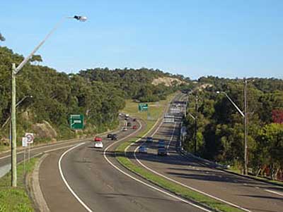
Southern Freeway (F6) near Waterfall
Southern Freeway
The County of Cumberland Scheme of 1948 outlined a Southern Freeway linking Sydney to Wollongong. It currently is designated as the F6 (Freeway Route 6) but as part of National Route 1, it is to be designated as M1 when alpha-numeric route marking is introduced. Of its total length only three sections have been built. The first is between Waterfall and Bulli Tops interchange, the second is between Wollongong suburb of Gwynneville to Yallah, where it rejoins the Princes Highway. Mount Ousley Road connects the latter two sections together with an interchange at Picton Road. These sections were completed and opened in July 1975.The Southern Freeway route starts at Waterfall in the north, taking more or less a parallel route with Princes Highway until the sprawling Bulli Tops interchange (with Appin Road (State Route 69) and Princes Highway). There it continues downhill, avoiding the steep Bulli Pass, as Mount Ousley Road (dual carriageway) and bypasses Wollongong CBD. The freeway re-emerges at Gwynneville and continues for 20 kilometres to Yallah where it rejoins the Princes Highway. The third completed section presently has no connection with the completed sections from Waterfall to Wollongong. This third sectionsd begins at and with the six-lane Captain Cook Bridge (connecting Sans Souci to Taren Point) and a short joining section of Taren Point Road from the bridge to where the roadway bends slightly before the Holt Road intersection.
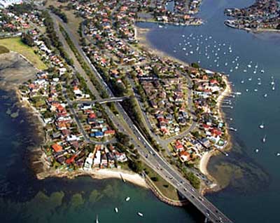
The completed third section at Taren Point
From here, the third completed section was designated to connect to the Waterfall end of the F6 via a reserved corridor that includes Port Hacking Rugby Field, Miranda Park, and entering Royal National Park in the vicinity of Hovea Place, Gymea Bay. Establishment of the bridge section of the F6 extension began in 1962, expedited to replace the ferry service that had operated from Taren Point to Sans Souci since 1916. Captain Cook Bridge was opened for general use in May 1965.
North of Captain Cook Bridge, the land reservation tract currently passes through the suburbs of Sandringham, Sans Souci, Ramsgate, Monterey, Kogarah, Brighton-Le-Sands, Rockdale, Banksia, Kyeemagh and Tempe. In the original plan, the F6 would end at Campbell Road, St Peters, which is today a crowded industrial area. It was then to be linked to a major interchange planned on the site of Wentworth Park, via the railway corridor, then north along the present path of Abercrombie and Wattle Streets. At this interchange it was to connect to the now abandoned North West Freeway to Gladesville, the Western Motorway to Penrith via Strathfield, and the city via the Western Distributor. As that interchange is no longer on the agenda, to entend the Southern Freeway north to Parramatta Road would create a congestion problem similar to that of the M4 Western Motorway, which ends at the arterial Parramatta Road in Strathfield.
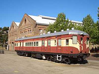
A disused railway carriage in the grounds of the Australian Technology Park on the planned route for the northern section of the Southern Freeway
The most recently proposed M4 East extension would extend the current motorway from Strathfield to the City West Link. The City West Link connects to Victoria Road, which joins the Anzac Bridge and then the Western Distributor. There has also been a proposal for an extension of the M4 East known as the "Inner-West Motorway", comprising a tunnel running underneath the Inner West of Sydney and connecting to the M5 East at St Peters. Thus, under the new plan, the F6 would connect to this proposed tunnel. Prior to the 2007 federal election, the Liberal-Nationals (Coalition) promised to allocate AU$20 million towards planning for the F6 extension. Although the Coalition did not win the 2007 election, the funding was once again promised at the subsequent 2010 federal election. This funding would ensure the project is "shovel ready" when funding becomes available.
The NSW Government recently outlined a $7 billion plan to link the M4, Victoria Road, City West Link and Sydney Airport using a network of underground tunnels.

A corridor set aside for the Southern Freeway passes through the middle of the suburb of Sans Souci.
A disused railway carriage in the grounds of the Australian Technology Park on the planned route for the northern section of the Southern Freeway
The most recently proposed M4 East extension would extend the current motorway from Strathfield to the City West Link. The City West Link connects to Victoria Road, which joins the Anzac Bridge and then the Western Distributor. There has also been a proposal for an extension of the M4 East known as the "Inner-West Motorway", comprising a tunnel running underneath the Inner West of Sydney and connecting to the M5 East at St Peters. Thus, under the new plan, the F6 would connect to this proposed tunnel. Prior to the 2007 federal election, the Liberal-Nationals (Coalition) promised to allocate AU$20 million towards planning for the F6 extension. Although the Coalition did not win the 2007 election, the funding was once again promised at the subsequent 2010 federal election. This funding would ensure the project is "shovel ready" when funding becomes available.
The NSW Government recently outlined a $7 billion plan to link the M4, Victoria Road, City West Link and Sydney Airport using a network of underground tunnels.
A corridor set aside for the Southern Freeway passes through the middle of the suburb of Sans Souci.