


EARLY COLONIAL SYDNEY
1790 - 1809
Period covered by this chapter - 1st July 1790 to 31st December 1809
Governors of the Early Colonial Sydney
26th January, 1788 to 10th December, 1792: Captain Arthur Phillip, Governor-in-Chief.
11th December 1792 to 11th December, 1794: Major Francis Grose administered.
12th December, 1794 to 11th September, 1795: Captain William Paterson administered.
Sept 11, 1795 to 27th September, 1800: Captain John Hunter, Governor of NSW and its dependencies.
28th September, 1800 to 12th August, 1806: Captain Philip Gidley King, Governor.
28th September, 1806 to 25th January, 1808: Captain William Bligh, Captain-General and Governor-in-Chief of NSW and its dependencies. In 1808, he was unlawfully removed from office by officers of the NSW Corp.
26th January to 28th July, 1808: Major George Johnson administered.
29th July, 1808 to 8th January, 1809: Major Joseph Foveaux administered.
9th January to 31st December 1809: Colonel William Paterson administered.
Upon Phillips departure on 11th December 1792, the colony of New South Wales entered a period of political instability in which three Governors fought a losing battle against the New South Wales Corps who used their power and influence to receive maximum benefit of the system at the expense of the convicts. The Corps was a unit of the British Army which had been founded in 1789 especially for service in New South Wales. It was not considered a rewarding part of the Army for career purposes and the standard of recruits suffered accordingly. The first detachment of 100 soldiers was dispatched with the Second Fleet and arrived in Sydney in June 1790; the second detachment, commanded by Major Francis Grose, arrived in 1792. During Grose's term as colonial administrator in the absence of a Governor, the Corps operated with relative freedom and developed great power within the colony with officers involved in trade and a traffic in spirits for which it was given the nickname of the "Rum Corps".
 John Macarthur is probably best remembered for his contribution to the Australian wool industry, but to his contemporaries he was well-known as a man determined to get what he wanted and not at all reluctant to oppose those who stood in his way. Gov. Hunter described him as restless, ambitious and litigious. His Australian conflicts started before he had even stepped foot on her shores. As a Lieutenant in the New South Wales Corps on the voyage out to Australia, Macarthur fought a duel with the captain of the Neptune and quarrelled with his successor.
 Gov Phillip and Major Francis Grose were on good terms with Macarthur, despite a small reprimand from Phillip. With, Gov Hunter, was a different matter. Macarthur became involved in a dispute with the Judge-Advocate, Richard Atkins, who issued a warrant for the arrest of Macarthur after he refused to answer a summons for allowing his schooner to come ashore unauthorised. Hunter took Atkins side. After a series of letters to London in which Macarthur severely criticised Hunter for the way he was governing the colony, Hunter was recalled to England.
The next quarrel in which Macarthur was involved was with Gov. King. The reason for the quarrel isnt clear, but appears to have related to legal proceedings. Macarthur tried to discredit King, but not everyone was easily influenced. His commanding officer, William Paterson, was so offended by Macarthurs words against King that he challenged him to a duel. King arrested Macarthur and sent him to England for trial, but the charges were vague and there were no witnesses. To rub salt into the wound, Macarthur was not only set free but brought back with him an order for the Government to issue him 5,000 acres of land and the pick of the Merino sheep from the Royal flock. It was this land grant and his distain for Kings replacement, William Bligh, who was annoyed at the grant having been made, which set the pair off on the wrong foot and escalated to a dramatic climax with the Rum Rebellion. These two very stubborn men, equally sure of their own rightness, were perhaps doomed to conflict with each other.
In the beginning of 1808, Bligh arrested Macarthur over his previous actions in resisting the warrant issued by Atkins over the schooner. The Captain of the NSW Corps, George Johnston, ordered Macarthurs release. When Bligh refused, Johnston marched on Government House, deposed Bligh and took command, giving Macarthur the post of Colonial Secretary. Macarthur returned to England in 1809, to support Johnston during his court-martial. Although Macarthur could not be prosecuted as he was a civilian, instructions were given to Gov Macquarie to prosecute Macarthur as soon as he returned to New South Wales. For this reason Macarthur stayed in England until 1816, at which time he returned to Australia. He began arguing with Macquarie over the granting of land but found in Macquarie an equally stubborn person as Bligh. Macarthur behaved in his usual way and tried to discredit the Governor and was instrumental in getting Commissioner Bigge to come to Sydney to review Macquaries Governorship. Macarthurs feuds with Governors seemed to stop there. He was on friendly terms with both Brisbane and Darling. Perhaps it would not be too far-fetched to suggest that they saw the wisdom of keeping Macarthur on side as they watched his behaviour become more irrational. Later in life, Macarthur was proclaimed insane.
 Grose (1758?-1814) joined the British army in 1775 and became a successful career Army officer. As a major in the 96th regiment, he was placed in command of the second detachment of the New South Wales Corps, and arrived with them in 1792 whereupon he was appointed lieutenant-governor of New South Wales. Unlike previous military leaders, he enjoyed good relations with Governor Arthur Phillip and when Phillip left for England in December 1792, Grose was appointed Acting Governor. During his time in office, the power and jurisdiction of the military and granting land to officers greatly increased. Unlike Phillip who had a plan for the orderly development of Sydney as a colony of settlers, Grose saw it as nothing more than a penal settlement under tight military control. He encouraged the officers' farming and trading activities and when he returned to England in 1794 to continue his Army career, their dominance over trade was firmly established.
 Paterson (1755 - 1810) was born in Scotland. A soldier and explorer, he was also an amateur naturalist who collected botanical, geological and insect specimens for Joseph Banks in Britain. He made several inland expeditions from Sydney. Paterson administered the colony of New South Wales in the absence of a resident Governor on two occasions, the first was from 12th December 1794 to 11th September 1795, relieving Major Grose as administrator when he left Sydney in 1794 until the return of Captain John Hunter to take up the Governorship. His second term commenced on 9th January 1809. He remained in the post until the arrival in New South Wales of the incoming Lachlan Macquarie a year later.
  Scotsman John Hunter (1737-1821) abandoned studies for the ministry for a career in the Navy to which he had given 30 years of active service when appointed second captain of the Sirius under Governor Arthur Phillip with the First Fleet. Hunter, who had a dormant commission as successor to Phillip should he die, was actively involved in surveying Port Jackson and the rivers and harbours of the Sydney area. In 1789, he took Sirius to fetch provisions from the Cape of Good Hope after the first harvest had failed. Returning in May 1789 after circumnavigating the globe, he continued to command the Sirius which was wrecked on Norfolk Island. The incident left Hunter and the crew stranded there for eleven months. Hunter returned to England in April 1792, saw service in the war with France until his appointment as Phillip's replacement following the latters resignation in 1793 because of ill-health.
 By the time of his arrival as Phillips replacement, in September 1795, the control of the colony had fallen firmly in the grip of the NSW Corps. Hunter was a gentle, humane and charitable man, and no match for the soldiers he tried to control. He loved Australia and though he had little impact on the growth of Sydney, he is remembered for his exploratory expeditions and his contribution to zoological and botanical sciences which included the discovery and documentation on the lyrebird and the koala. Hunter was very pro-the convicts to whom he showed sympathy and humanity, especially their wives and children. He fell foul of the NSW Corps and John Macarthur in particular and was eventually recalled because his administration was considered a failure. He published Remarks on the Causes of Colonial Expense of the Establishment of New South WalesÓ (London, 1802), which vindicated him and successfully promoted the view that the Government had been misinformed on many matters to do with the Rum Corps". His replacement was another first fleeter, Captain Philip Gidley King. Hunter returned to naval command in 1804.
 Philip King (1758 - 1808) was born in Launceston, Cornwall, and joined the Navy at the age of twelve. He saw active service in America and joined the Channel Fleet in 1780 where he served under the command of Captain Arthur Phillip who chose King as second lieutenant of HMS Sirius for the First Fleet. King was sent to establish a settlement at Norfolk Island within two weeks of their arrival. The venture was a success and King was promoted to Lieutenant-Governor of Norfolk Island, althoug by that time - March 1790 - Governor Phillip had sent King on a brief but successful visit to London to discuss the problems of New South Wales. Upon his return, King suffered conflict with some of the New South Wales Corps and clashed with the acting governor, Major Francis Grose.
 Because of ill-health, he returned to London for a period of leave in 1796. Supported by Sir Joseph Banks and John Hunter, he was again appointed to succeed Hunter as Lieutenant-Governor of New South Wales. Highlights of his six years in office include improvements in agriculture, health, education and relations with the Aborigines. Exploration with a view to establishing further settlements was always high on his agenda. Because of further ill-health, King was replaced as governor by William Bligh in 1806, and he left for England in February 1807.
 1795 has significance in the history of Australian exploration and discovery as it was in that year that 21 year old Matthew Flinders (right) first set foot on Australian soil and began a series of voyages in which he would become the first person to circumnavigate Australia, prove that Tasmania and mainland Australia were islands and suggest the name Australia. On the voyage out he struck up a friendship with ships surgeon Gorge Bass. Captain Hunter, under whom Flinders had served a few years earlier, was now Governor of New South Wales. He equipped them with a small boat named Tom Thumb and together they embarked on a couple of local voyages of discovery, the most significant of these being around Botany Bay, Georges River and Port Hacking.
 In 1798 Bass and Flinders sailed their last journey together on the Norfolk on a voyage in which they proved that Tasmania was an island by circucmnavigating it. After completion, Flinders returned to England to be married but within a short time he was given orders to return to New South Wales to complete the charting of the Australian coastline. The two year saga proved to be the voyage of his career. As Master of the Investigator, he filled in the missing sections of coastline on the map of Australia and became the first man to circumnavigate the country. On his way home he called into Mauritius, unaware that France and England were at war. Flinders was suspected as being a spy by the French authorities and was held prisoner for nearly seven years. He returned to England in poor health and died on 19th July 1814,
 Portsmouth born Bligh (1754 - 1817) joined the navy in 1770 and sailed with James Cook on the Resolution in 1776. An excellent navigator and cartographer, he brought the vessel home after Cooks death in Hawaii. Blighs most famous voyage was aboard HMS Bounty. While travelling to Tahiti to collect breadfruit plants and take them to the West Indies he was overcome by mutineers. Bligh and his fellow officers were cast adrift in a longboat and left to die but Bligh's navigation skills eventually brought them to safety in Timor, having charted the north-east coast of Australia as he went.
 Bligh was tried for the loss of his ship when he returned to London but was acquitted. Through the support of Sir Joseph Banks, he was offered the Governorship of the colony of New South Wales and took up the post in 1806. Within weeks of his arrival in August 1806, Bligh had made it clear he would not tolerate the corruption of the NSW Corps and vowed to destroy their control of the import
ation of spirits and domination of economic life in the colony. He brought the matter to a head by arresting John Macarthur over his previous actions in resisting a warrant issued against him. Outraged by Blighs actions, a unit of the NSW Corps led by their Commanding Officer Major George Johnston who was sympathetic to MacArthur marched on Government House in Sydney on 26th January 1808 and demanded Macarthurs release. When Bligh refused he was placed Bligh under house arrest.
Bligh was eventually released and returned to England, the administration of the colony being placed in the hands of Major Joseph Foveaux and later Colonel William Paterson until the arrival of Brigadier General Lachlan Macquarie as Blighs replacement. Macquarie brought with him the 73rd Regiment of the Royal Highlanders as the garrison force of the colony. The New South Wales Corps was disbanded, effectively ending their infamous reign.
Major Johnson was supported by settler John Blaxland in that he (Blaxland) believed Bligh had manipulated and reshaped the courts of the colony into instruments of oppression, applying law in contradiction to set English law in order that the Governor's will be satisfied in all cases. Bligh's assertion that the Rum Rebellion was a direct result of Macarthur's actions regarding the spirits prohibition was believed by the British courts in preference to Macarthurs and Johnstons arguments, however some historians have questioned the validity of Blighs argument. They allege that the monopoly of spirits and foreign exchange by the New South Wales Corp had effectively ceased to exist after 1800 when eighteen settlers, other than officers, petitioned Governor Hunter for permission to purchase the cargo of the 'Minerva'. They also cite the arrival of Robert Campbell, a free merchant, in the Colony, with his own sources of foreign exchange as a further factor in the collapse of the Corps monopoly but play down the fact that Macarthurs warrant was issued over a trade related matter.
Nevertheless, the Home government was very unsympathetic to the rebellion; Johnston was court martialled, leading to his dismissal from the Army, and John Macarthur who returned to England in 1809 was forbidden to return to Australia until 1817. Bligh was cleared of any wrong doing and continued his career in the navy. He was promoted to Rear Admiral in 1811 and Vice Admiral in 1814. He died in London three years later.
 Foveaux (1766-1846) was baptised in Millbrook Church, Bedfordshire, England. He entered the British Army as an ensign in the 60th Regiment in May 1789, purchasing a Lieutenancy in the New South Wales Corps in June 1789, and a Captaincy in the same regiment in April 1791. Foveaux was appointed Commandant at Parramatta, effectively making him the civilian as well as military Commander for twelve months from May 1792. He was Lieutenant-Governor of New South Wales from September 1796 to September 1799, and Lieutenant-Governor of Norfolk Island from 1800 to 1804, although he continued to be paid in the post until 1807. In 1799 Foveaux was granted 300 acres in the Baulkham Hills area which he sold to John Macarthur in 1801. The Macarthurs farmed sheep on this property before establishing them at Camden.
 Foveaux relieved Major George Johnson as Colonial Administrator in July 1808 and was himself relieved in January 1809 by William Paterson due to ill health. He had strong views on reform which he believed were necessary to ensure the viability and growth of the colony and made a successful attempt to reach England with his account of the Rum Rebellion before Bligh did.
At the time of Macquaries arrival, the signs of Sydney's progression from a convict camp to a colonial settlement were becoming evident. The first free settlers had arrived in 1793 on the Bellona, eight years after the arrival of the First Fleet. These newcomers, the first in a long stream of free settlers to join a growing number of emancipists who were making a new start for themselves, played an ever increasing role in the transformation. A brewery had been established some years earlier in Castlereagh Street which complimented a similar, even earlier business establishment at Kissing Point (Ryde). Three windmills dominated the skyline, one above Farm Cove, the others were to the west on Miller Point beyond Fort Phillip. Brickfields village had become a hive of activity with numerous businesses engaged in the manufacture of pottery, crockery, roofing tiles and bricks. A tannery there supplied the cattle and kangaroo hides used by a factory in Pitt Street in the manufacture of boots and shoes. The Government lumber yard in what is now George Street had been extended to include a forge where iron and steel being imported from England was used in the manufacture of tools and implements. The Rocks area was fast becoming a re-fitting port for the growing number of British and American sealing and whaling vessels visiting the colony.
Despite the plan so carefully laid down by Gov. Phillip, Forveauxs description of Sydney indicates that it had become a disorderly place with no defined direction. The public buildings are in a state of shameful dilapidation, and rapid decay. The streets of Sydney are almost impassable, and the roads and bridges are, if possible, in still a more dangerous and neglected state.Ó Early settlers had chosen to take shortcuts through the bush rather than follow the streets, turning the colony, particularly The Rocks ar
sea, into a maze of ad-hoc thoroughfares. Though Forveaux documented the problems well, it was Governor Macquarie who addressed them, and in doing so, gave Sydney a new direction.

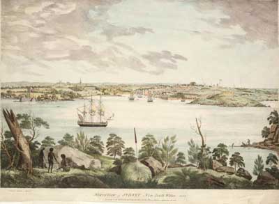
Map of Sydney, 1802
During Sydneys first year, travel and transportation for all but the Governor and his officials was non existent. That is hardly surprising, given that the settlement was after all a gaol for Englands outcasts, and the purpose of a gaol is to be confining. The British Government which orchestrated the project must have been well aware of this as they made sure there wasnt a single horse in the menagerie of animals sent with the First Fleet (Phillip bought four mares and two stallions at the Cape of Good Hope on the journey out; a further ten arrived with the Second Fleet). In fact, it wasnt until the arrival of some free settlers who began importing horses from India that animals were used as a means of transport in Sydney.
There were boats, but these were all under the Governors jurisdiction and their use was restricted to exploratory expeditions up and down the harbour. Under the rules of the colony during the first year, private ownership of boats was not allowed, and to avoid them falling into convict hands and them being used for escape, the Governors boats were guarded by armed Marines.
By October 1788, the first boat built in the colony was launched at Campbells Cove. Named The Rose Hill Packet but affectionately known as The Lump, it was a flat-bottomed barge designed to ply the Parramatta River between the two settlements. On its maiden voyage, it returned from Rose Hill with the areas first harvest, amounting to some 200 bushels of wheat, 35 bushels of barley, and a quantity of maize. Many a boat would be built on the shores of Campbells Cove until well into the 19th century when Balmain, Woolwich and Cockatoo Island became the centres for boatbuilding activity on Sydney Harbour.
The success of The Lump's first run had the effect of turning the Parramatta River into a busy waterway. The journey between Sydney and Parramatta was quicker and easier by boat than by land and it was the subsequent ferry services operating on this route that initiated in Sydney the same social change that railways initiated in England. The farming district of Ryde, a whaling industry on Mosman Bay and the shipbuilding activity on the shores of Balmain all came into being as a result of their ease of access to Sydney by boat.
The Georges River
Apart from the official cross country expeditions, early access to the outlaying areas of Sydney in the vicinity of what are now the Bankstown, Liverpool and Macarthur districts was exclusively by boat up the George River, which rises near Appin. The area was opened up to farming in consequence to explorers Matthew Flinders and George Bass navigating the river in 1795. After sailing to beyond where Liverpool now stands, the pair returned with glowing reports of the area as potential farming land and of the navigational possibilities of the river. This led to land being granted between 1798 and 1805 on the alluvial flats on a bend in the river that is now Moorebank and Chipping Norton. By the turn of the Century, transportation of local produce by river had led to the development of a settlement at the furtherest navigable point of the river for coastal trading vessels. When Gov. Macquarie first journeyed to the newly settled district upon his arrival in NSW, he was so impressed by the settlements potential as a regional centre, he laid out a town there and named it Liverpool.The Nepean/Hawkesbury River
The first area to be settled beyond Sydney and Parramatta was the Nepean/Hawkesbury. (The Nepean and Hawkesbury are in fact the same river, but a section was discovered and named the Nepean by Capt. Watkin Tench in 1789, unaware that it was the upper end of the Hawkesbury which had been explored and named some months before). As the alluvial soils of the district were found to be particularly fertile and the colony at the time had little fertile land suitable for agriculture, the Governor opened up the area for faming as quickly as possible. By 1794, settlers had moved into the Hawkesbury and the township of Green Hills (later named Windsor). The town, which was laid out and renamed Windsor by Gov. Macquarie, became a local centre for the transfer of produce and goods between Sydney and the region.The river trade developed quickly and came into its own with the introduction of steamers in 1831. By 1800 the Nepean district had been settled though land was not formally granted until 3 years later. For many years, it was considered to be among the best grazing land in the colony. Records indicate that 66 grants had been made on the Nepean and South Creek by 1806.
Though there were no walls around the settlement to keep the convicts in, the settlement was very confining, particularly in the first few months, as the bush which encircled the settlement was very much an unknown quantity. Rumours spread among the convicts that China was not far away, perhaps on theb other side of the Blue Mountains and a number tried to make a dash to freedom. Most we quickly recaptured after wandering around aimlessly in the bush without food and water. As the colonists ventured out from Sydney Cove, they came across many paths used by the Aborigines to travel from one part of their tribal grounds to another. One of the first tracks they would have discovered led from the swamps at the source of their settlements stream (near Hyde Park) to more swamps to the south east, later to be known as Lachlan Swamps. They became Sydney's second water supply when the stream became polluted. 100 years later they would become the ornamental lakes of Centennial Park.
This path had been used for centuries by the Aborigines to get from one watering hole to another. The white settlers used it for a similar purpose, and it became South Head Road (later renamed Oxford Street), the main thoroughfare to the south east of Sydney. This path was one of many well worn tracks which criss-crossed the area, inter-connecting the various camping grounds and water holes used by the Cardigals. These tracks, which were later given names like Cleveland Street, Botany Road, Old South Head Road, Alison Road, Belmore Road, Coogee Bay Road, Bronte Road, Anzac Parade, Bunnerong Road, Stoney Creek Road, Rocky Point Road, Stanmore Road, New Canterbury Road, City Road and Princes Highway, Liverpool Road, Canterbury Road and Georges River Road, gave the white settlers access to all the land to the east of Sydney right to the ocean and to the south and west as far as Botany Bay and the Georges River.
As Sydney grew, farms and settlements were established by the emancipists on either side of these tracks around the water holes and creeks along the way. Ironically, these tracks, which had been the lifelines of Aboriginal society for centuries by linking their limited food supplies, were the means by which their culture was decimated when they fell into the hands of the white settlers. The Aborigines were forced to move into other areas or lose their identity altogether by attaching themselves to the fringes of the encroaching culture as it destroyed the environment that had sustained them for centuries.

Parramatta Road toll gate
As land was opened up around the settlement area, new roads were cut through the bush and where these roads crossed water courses, simple bridges were built, though no records of when and by whom they were built have survived. The first cross country road of any consequence was a track linking Sydney and Parramatta which became Parramatta Road. All travel by officials of the colony between the two settlements was made by boat up the Parramatta River and the early governors actually discouraged cross country travel between the two locations. But the building of a road was inevitable as the first land grants outside of Sydney itself were between Sydney and Parramatta and a road was needed to gain access to them.
The track was cut through the bush from Brickfields to Parramatta between 1789 and 1791. It appears to have been well patronsied, as in September 1805, tenders were called for the carrying out of repairs to Parramatta Road and the bridges over which it passed and for the erection of new bridges at the following locations: between Grove Farm and Major Johnstons; opposite Major Johnstons paling; corner of Whites Farm; at the foot of Prentices Hill; corner of Capt. Roleys paling; next to Hackings Creek; Hackings Creek; Blankets Ridge; Capt. MacArthurs Creek (Duck Creek); Becketts Bridge.
The opening up of farming land beyond Parramatta in the 1790s necessitated the building of more roads to service the settlers moving into these new areas. Parramatta soon became the overnight stopping place for travellers passing on to the outlying districts. The road from Parramatta to Windsor via Toongabbie, known today as the Old Windsor Road, was built in 1794, followed shortly after by a road to new settlements at Castle Hill. Beyond Windsor were the fertile regions of the Hawkesbury, which weresettled by farmers even before the road was completed. When French naturalist Francois Peron visited Sydney in 1802, he wrote a detailed description of Sydney which included a map showing the major thoroughfares and the four bridges which existed at that time in Sydney and its immediate surroundings. These bridges are detailed below, followed by the known information on some other major bridges in the colony outside of Sydney which existed at that time.
1788 - Tank Stream Bridge
The first bridge over Sydney's main water supply was a simple log bridge erected in October 1788. It was replaced on numerous occasions with more substantial timber structures. In 1803 Gov. King asked the semi- retired Augustus Alt to have the log bridge replaced by a more sturdy stone arch tall enough for small sea-going vessels to pass under it. King laid the corner stone for the new 9m long bridge at roughly where Bridge Street intersects Pitt Street today.Continual rock hewing activities by convicts for government buildings and public works had sapped the strength of the few able bodied men capable of carrying out the erection of the bridge. This led Gov. King to appeal to the colonys free settlers to help in its construction. Struggling to survive a drought, colonists refused point-blank to labour on the bridge under the hot sun, and the job was left to five convicts supervised by stone-mason Isaac Peyton. Built in haste, it was opened to traffic on 5 January 1804 but collapsed nine months later due to a combination of poor workmanship and heavy rains which caused the creek to flood. Repairs were under taken immediately and again in 1806. The road which crossed the Bridge, formerly known as Governors Row, was named Bridge Street by Gov. Macquarie when he renamed Sydney's streets in 1810. In the following year he had the bridge completely remodelled by John O'Hearn, which included widening and lowering of the arch. O'Hearn's labour was paid for with 675 gallons of rum. The bridge was demolished in the 1840s when the Tank Stream was channeled underground and the area beyond the bridge reclaimed and remodelled as part of the construction of Circular Quay.
1791 (?) - Brickfields Bridge
Though no official records indicate the exact date of construction of the first simple log bridge, it carried the road to Parramatta across a stream which flowed from Surry Hills into Darling Harbour, therefore it would have had to have been completed by 1891. Contemporary maps place this bridge as being somewhere near the present day intersection of Hay and Pitt Streets. The section of Pitt Street between Hay Street and Railway Square was originally the beginning of Parramatta Road and began at the bridge. The water course began as a spring near present day Clifton Reserve in Surry Hills. Little Albion Street follows the path of the stream which cascaded down the hillside on the Western side of Crown Street in what became known as Frog Hollow. A settlement sprang up in this small valley and it became a notorious hideout for criminals in Victorian Sydney.According to Peron's map, a bridge also existed over a creek which flowed into Darling Harbour on its Western side. Located in the vicinity of the overpass taking the Western Distributor over Pyrmont Street, the path which crossed the creek at the bridge provided access to the farm of Surgeon John Harris and followed the line of Harris Street. Another bridge took Parramatta Road (then Parramatta Street) over Black Wattle Swamp Creek. Present day Blackwattle Lane follows the creeks course. Perons map also shows a bridge had been built to take a road over a creek which followed the line of the Domain Ridge and emptied into Woolloomooloo Bay. The road was to become William Street. The bridge, which was located in the vicinity of the intersection of Yurong and William Streets, is recalled in the name of Stream Street. The latter follows the path of a small section of the water course which rose in the hills of East Sydney near Liverpool Street.
1802 - South Creek Bridge, Windsor
The first bridge at Windsor carried the new road between the Hawkesbury settlement and Parramatta across South Creek. In use between 1802 and 1814, it was a floating pontoon bridge built by Andrew Thompson, a settler and constable at Green Hills. He took up a grant there in 1786 and in doing so opened up the area. Thompson was given permission to charge colonists to use the bridge as he had paid for its construction. Gov. King contributed £15 and provided two convicts for a period of three months to assist in its erection in return for free travel across it by government officials, officers and soldiers on duty. The bridge was replaced in 1814 with a free-access low-level timber beam structure which, at 66m, was the longest bridge in the colony at the time. Known as Howes Bridge, after its builder, John Howe, it survived until 1853 when a high level bridge consisting of three laminated timber arches replaced it.1804 - Chapel Street Bridge, Parramatta
A simple single lane timber bridge built by convicts at the spot where Church Street (then known as Chapel Street) crosses the Parramatta River. It was financed by contributions collected by the Governor from local residents and was eventually replaced in 1836 by the Lennox Bridge.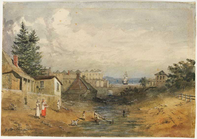
The Tank Stream
One of the major influencing factors in Phillips choice of Sydney Cove above other bays in Port Jackson for the site of the settlement was a little ferny creek. It flowed north from swampy high ground located within the area bounded by Market, Park, Elizabeth and Pitt Streets through a small, closed valley and into the cove through a tidal estuary. It was fed and filtered from the seepages of mosses and undergrowth that provided the spongy cover of its porous sandstone base. Sydney Red Gums (Myrtles), Banksias, Acacias (Wattles), Cabbage Tree Palms and Tree Ferns shaded an undergrowth of orchids, ferns, plants and flowering shrubs which thrived in the shaded environment of rotting leaves, bark and boughs of fallen trees. The nature reserve of Parsley Bay at Vaucluse, some six kilometres west of Sydney Cove, with its riverlut, small closed valley and rainforest vegetation, gives an inkling as to what Sydney Cove of 1788 must have been like, being today much as it was when Captain Philip first found it. A wander through this reserve is like a walk back in time.
A definite channel through which the water could flow was formed from King Street. A small weir was built to catch the water and to stop rising tides from making the water salty where Pitt and Crane Streets intersect today. A simple log bridge was built across Tank Stream near the the military barracks, giving rise to the walkway which later was to cross the stream at this point being named Bridge Street. In 1804, Gov. King had the log bridge replaced by a more sturdy stone bridge It was remodelled in 1810 by John OHearne whose labour was paid for with 675 gallons of rum.

The Tank Stream tunnel
So where is the little rivulet that once flowed into Sydney Cove? The first settlers did not realise that clearing the trees and underbush loosened the topsoil which kept the mosses, ferns and undergrowth in its moist state. Within two years, the creek had become polluted. Construction of new dwellings in the 64 Ha catchment area was belatedly banned and tanks were built near Bridge Street to retain what little water still flowed, hence its name Tank Stream. In 1804, a last ditch effort was made to protect the stream. The Governor declared a 15-metre wide green belt on either side of the stream where cutting timber and grazing stock was forbidden, but the damage already done was irreparable. By 1826, Tank Stream had ceased to be used as a water supply, being replaced by an underground channel which brought water from Lachlan Swamps in Centennial Park to a reservoir in Hyde park.
As there was no need to retain what was left of the stream, the land around it was sold and developed, and what was once the lifeline of the town became an underground drain. The system of tunnels through which Tank Stream flowed into Sydney Cove still exist today, taking away the excess rainwater from Sydneys streets .A brick section of the tunnel between Angel Street and Australia Square is over 120 years old. When Australia Square was built, Tank Stream was diverted around the new buildings foundations via a new concrete tunnel. Today its memory is recorded in the names Tank Stream Way, Tank Stream Arcade and Bridge Street. The latter was thus named because it once crossed a over the creek at the spot where Tank Stream Way and Bridge Street now meet.
From the day of his arrival at Port Jackson, in accordance with his instructions Governor Phillip did everything within his power to maintain as friendly a relationship as possible between the white and Aboriginal communities that would now have to share the land around the Sydney basin. There was never any intention or attempt to wipe out the Aborigines, to invade or conquer them and any such outcome which modern day Australians might determine as having occurred is based on our hindsight view of the outcome of the arrival of white man rather than the intent of the first arrivals. Such a view is the result on an ongoing lack of understanding of each culture by the other, which commenced with the first meeting of Aborigines of the Sydney area and Cooks crew, and which continues to this day. Phillip and the other First Fleeters took the traditional but erroneous European view that the Aborigines were savages of inferior intelligence, lacking in culture and education.


